Welcome to North Survey Instruments Llc
Manufacturer / Exporter / Supplier Of Digital Planimeter, Laser Range Finders, Laser Range Finder, Binoculars
-

Sales Manager
Farhan Mohd
-

Primary Business
Supplier
Manufacturer / Exporter / Supplier Of Digital Planimeter, Laser Range Finders, Laser Range Finder, Binoculars
Sales Manager
Farhan Mohd
Primary Business
Supplier

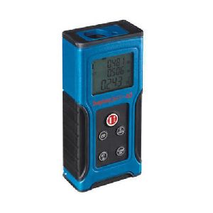
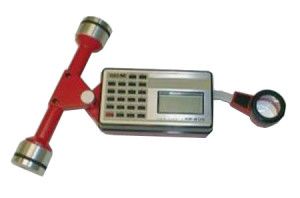
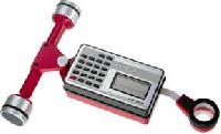
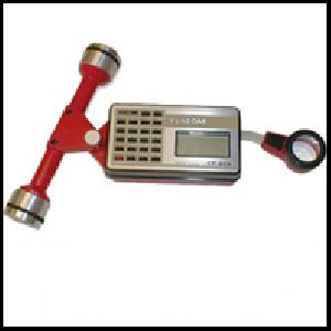
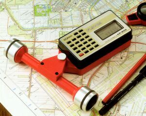
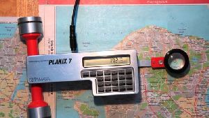
Digital Planimeter Offered in a roller-type model this planimeter features a unique 6-digit pulse count operation that permits cumulative measurement of areas up to 10m-100 times the measuring capacity of ordinary planimeters. Enhanced with advanced micro-processors for accuracy, this instrument is ideal for many applications where precise large area measurements are needed, such as in civil engineering, surveying, forest management, mapmaking and agriculture. Other features include hold and measuring control, clear liquid crystal digital readout, and scale readings in either Metric or English. Comes packaged in a plastic carrying case with AC adapter (battery included) and operating instructions. Features easy roller operation - simply follow the outline of the area to be measured, the reading on the digital display corresponds to the circumscribed area. Please note: No. KP90N has a computing function that gives the measurement readout in the scale desired (sq.ft., acres, etc.). Specifications: Max. measuring range: 325mm vertical; 30m horizontal Accuracy: within ±0.2% (within ±2/1000 pulses) Includes Manufacturers 1 Year Warranty.

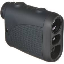
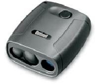
Offering Laser Range Finders. It's almost an insult to even call these powerful measurement tools a "Laser Rangefinder" because thier capabilities go far beyond just measuring a range. You can instantly measure slope distance, inclination and azimuth* and calculate horizontal and vertical distance - all with a single push of a button. TruPulse 200L & 200X laser range finders TruPulse 200L and 200X Laser Rangefinders The new TruPulse 200L is a professional laser rangefinder for a consumer price. The built-in inclinometer (tilt sensor) allows the user to measure horizontal distances to extremely far targets. The 4X magnification optics makes this unit ideal for tree height measurements. To complete the TruPulse product line, the new TruPulse 200X is very accurate, ruggedized waterproof unit ideal product for any type of environment. The new bright red LED display is perfect for those low light measurement conditions. Also new to the product line is adding a Bluetooth module that is compatible with iOS devices as well as Android & Windows Mobile. Our Missing Line Routine is incorporated into all TruPulse models. The TruPulse 200 Series Missing Line routine is a 2D measurement. Taking 2 shots to remote targets calculates the distance & inclination values between those 2 remote targets. TruPulse laser range finders TruPulse Laser Rangefinders TruPulse 360 Series has an integrated compass that allows you to measure azimuth which enhances the Missing Line routine. This is a simple 2-shot routine that instantly calculates the distance, inclination and azimuth direction value between any two remote points. Using our exclusive TruVector Compass Technology™ built in the TruPulse 360 Series, you can now obtain the best possible azimuth accuracy regardless of what pitch or angle you shoot from. No other compass laser range finder can do that. The 360 R laser rangefinder offers all of the same functionality as the 360 B, but with the added benefit of being rugged and waterproof. Now professionals have the opportunity to work out in the field knowing their equipment is protected for harsher weather conditions. All TruPulse laser rangefinders have onboard solutions that will calculate a height or clearance value of any target, under the most challenging conditions and also have builtin Targeting Modes for Closest, Farthest, Continuous and Filter/Reflector. Use the 3-shot Height routine for upright targets like phone poles or buildings, even when the top or base may be obscured. The Vertical Distance and Missing Line modes are perfect for leaning objects such as most trees you encounter; and for clearance values of a wire or bridge over a roadway. For downloading data into any compatible device, you can use the standard** RS232 serial port or Bluetooth® wireless communication that is in most models. Each shot taken automatically downloads a full data string that comprises of horizontal, slope and vertical distance, the degree of inclination, and azimuth* values. These measurements can be used to remotely position a target when integrating with GPS or add a height value as an attribute in GIS. For more stability, use the¼”-20 thread for mounting the TruPulse laser rangefinder on a staff or monopod. Having superior optics and in-scope data display, you'll always be confident you are capturing the right measurement to the correct target. If your measurement were ever in question, you can toggle on the Closest or Farthest Mode to ensure the laser sensor is ignoring unwanted obstructions that are either in front or behind your desired target. TruPulse laser range finder displaying data TruPulse Laser Rangefinder displaying data in scope What else can we say about the TruPulse laser rangefinder? What about its compact size and low price point? When you consider this size being small enough to fit in your vest pocket and how customers have claimed it paid for itself within their first project, there is no question that the TruPulse laser rangefinder is one of the best measurement tools in the world. How the TruPulse Laser Rangefinder Measures Up: Measures distances, height, missing line* and azimuth*. Fits inside a vest pocket and is very economical. Displays all measurements and menus right in the scope. Integrates with GPS and popular GIS software**. *Applies to only the TruPulse 360 laser rangefinder ** TruPulse 200L does not have serial or Bluetooth communication
Share your thoughts with other customers for North Survey Instruments Llc
Add Review